
![]()
Some Files require
Adobe Reader
![]()
|
Spring Creek County, Montgomery County, Texas |
|
|
|
There was a nice article
in
The Woodlands Lifestyle & Homes, March 2016 on
Spring Creek County,
p 39. Included also is my correspondence with Trevia Beverly in 2010 on
the location of the boundaries of Spring Creek County using the
Atlas of Historical Boundaries
from Newberry Library in Chicago. An
awesome resource. The interactive maps are
currently unavailable as of January 2017 but should be back on line
soon. |
Back When � Spring Creek County
|
|
|
|
|
|
|
|
|
|
|
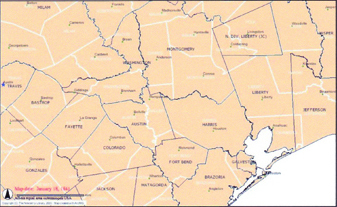
On Nov. 17, 2015, a forgotten part of Texas
history was brought to light and honored with a Texas Historical
Commission Marker. Spring Creek County was one of 16 �Judicial� counties
established between 1840 and 1842 to provide better access to citizens
when conducting government business, such as recording deeds, paying
taxes, court proceedings, and other business activities. In the early
days of Texas, the County Courthouse was where the real business of
government took place. |
|
William Pierpont, Isaac Decker, James Cooper,
George W. Cropper, Abram Roberts and Archibald Smith were named County
Commissioners. James Cooper was appointed Chief Justice (County Judge),
and on May 8, 1841, the following officials were elected: District Clerk
William B. Reeves, County Clerk Thomas M. Hogan, Coroner Jason Whitney,
Sheriff Alexander F. Barron, Surveyor Eugene Pillot, and Justices of the
Peace Henry T. Mostyn, Claude N. Pillot, Nathaniel J. Carrol, Samuel
Davis, James Dickson and John Simmons. |
|
On February 4, 1842 the Republic of Texas
Supreme Court ruled that the 16 judicial counties, including Spring
Creek County, were unconstitutional because they did not have separate
representation in Congress. The areas of these counties were then
returned to their respective parent counties. Many former judicial
counties were recreated after statehood in 1845. Spring Creek County is
the only one whose territory remains almost entirely within its parent
counties. |
|
������ |
|
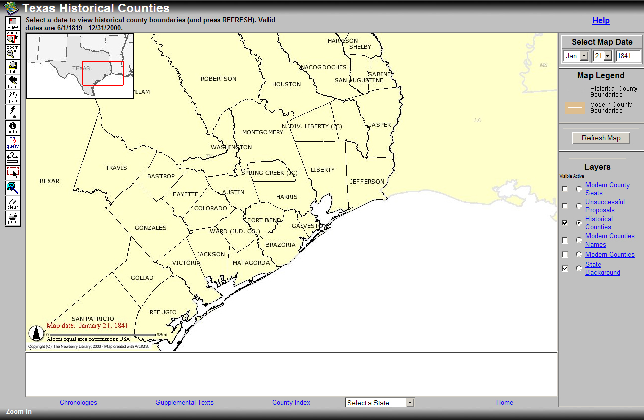
treviawbeverly <treviawbeverly@comcast.net> to: Jean Smoorenburg <jsmoorenburg@gmail.com>, Mike & Jane Keppler , <relppek91@gmail.com> Barbara Franz <bfranz@countylibrary.org> date: Sun, Nov 7, 2010 at 11:56 AM Do I understand that someone is writing a new history of Montgomery County? Name & Contact? ----- Original Message ----- From: Mark Lambert To: 'treviawbeverly' Sent: Wednesday, May 19, 2010 1:23 PM Subject: RE: Spring Creek County Folks: This is the second time in a year this question has come up. Attached is the statute from Gammel creating Spring Creek County in 1841. We have an unprocessed collection which we received in 2002 that includes a photocopy of a map of a part of Spring Creek County. The donor was a Mrs. Ann Q. Wilson, who at one time was researching the Atascosito Road. The attached map is entitled "Part of Spring Creek County taken from Harris County." We have nothing showing the full dimensions of Spring Creek County, but I guess you could start with the attached two items and make it yourself! Full information on the attached map is below. No one knows where the original of this map resides, though I would check Harris County Surveyor Records! Subject: County Maps Title: Part of Spring Creek County taken from Harris County Region: Gulf Coast County: Harris, Spring Creek Creation Date: January 1, 1842 Author/Creator: George H. Bringhurst, County Surveyor of Harris County. Publisher:??? Size: 11 x 17. Scale: 4000 varas to the inch. Format: photocopy negative General Features: [land holdings?,] roads, rivers, creeks Named Features: ???? Collection: Ann Q. Wilson Collection Comments: Archives also has a positive image of this same map, minus the top left corner. The location of the original of this map is not known. The map shows three roads in the northern part of Harris County believed to not be shown in any other map. The map shows the Grimes Road and the fork in that road on the Abraham Roberts Survey (Harris County Abstract #63) where the southern route to Harrisburg was taken by the Texas Revolutionary Army under Sam Houston on the way to the battle of San Jacinto in 1836. The map also shows the Groce-Rankin Road and the eastern extension of the Atascosito Road. One of my staff says we do have a record of one person registering their county of residence as Spring Creek County in our records, but I wouldn't know how to search for it in our online database since the county does not exist, but can figure it out if you need it. That's all! Good luck! Mark Lambert ~~~~~~~~~~~~~~~~~~~~~~~~ Mark Lambert, MLIS, MA, CA Deputy Commissioner Archives and Records Texas General Land Office 1700 N. Congress Ave., Suite 130 Austin, TX 78701 (512) 463-5260 (512) 475-4619 fax mark.lambert@glo.state.tx.us Visit our website: http://www.glo.state.tx.us/archives/archives.html |
|
There is nothing new in the world except the history you do
not know. Harry Truman
Hope the map of Spring Creek from the Newberry Library in
Chicago
http://historical-county.newberry.org/website/Texas/viewer.htm
helped you. |
|
|
Vote Montgomery County TXGenWeb County of the Month
|
Montgomery County Texas Banner graphics were designed by and remain the property of Jean Huot Smoorenburg. If you are being charged to view/use any of this information or have questions or comments, please contact Jane Keppler. |
|
|
|
Copyright � 1997
- 2023 by
Jane Keppler.
This
information may be used by individuals for their own personal use,
libraries and genealogical societies. Commercial use of this information
is strictly prohibited without prior written
permission
from
Jane Keppler.
If material is copied, this copyright notice must appear with the
information and please email me and let me know.
Neither the Site Coordinators nor
the volunteers assume any responsibility for the information or material
given by the contributors or for errors of fact or judgment in material
that is published at this website. |
|
Page Modified: 01 January 2023 |